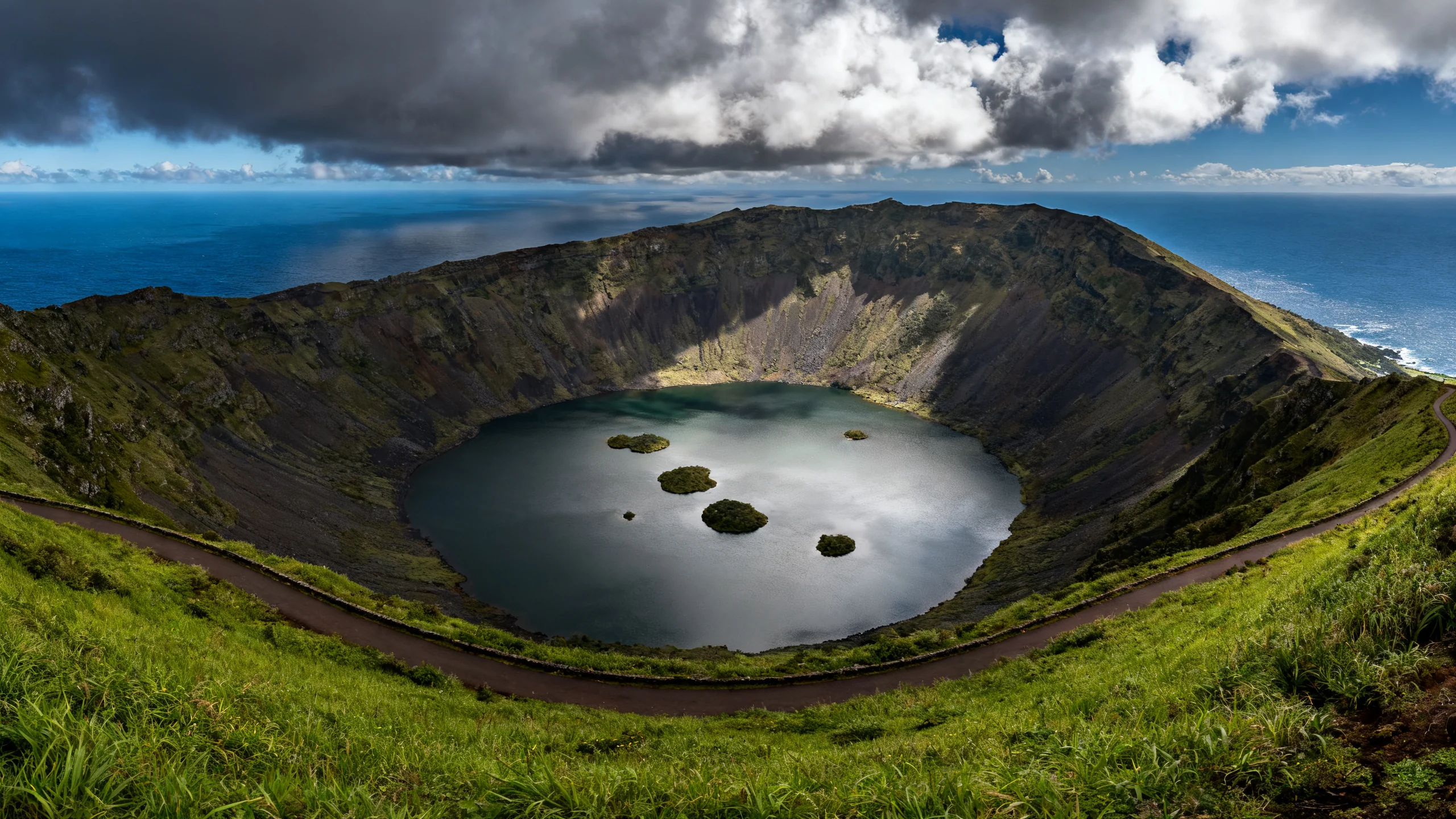
The Caldeirão of Corvo
The Caldeirão is essentially the entire island of Corvo: a single volcanic crater 2 kilometres wide with a small lake and a cluster of islets at its centre. The 7-km rim walk is the only proper hike on the island and the principal reason most visitors come.
The Caldeirão, in numbers
| Item | Detail |
|---|---|
| Rim altitude | 720 m at the highest point (Estreitinho) |
| Crater diameter | 2 km wide, roughly circular |
| Crater depth | 305 m from rim to lake |
| Lake (Lagoa do Caldeirão) | 0.5 km diameter, around 20 m deep |
| Islets in the lake | 2 main groups, 7 islets total |
| Last eruption | Around 80,000 years ago |
The rim walk (PR 1 COR)
A 7-kilometre loop along the rim of the crater at 600 to 720 metres altitude. Trail-marked with red-and-white poles. Three distinct sections.
Lower section (350 to 600 m, 45 minutes). The trail starts at the EN1 endpoint, climbs through low scrub and pasture, then steepens to gain the rim. Cattle often graze on this lower section. The path is steady but not steep.
Rim section (600 to 720 m, 75 minutes). The main event. The trail follows the rim around the crater, with continuous views into the bowl and out to the surrounding ocean. The highest point is Estreitinho (720 m); from there the rim drops gently on the eastern side. Several stone benches mark photo stops.
Descent (60 minutes). The east side of the loop returns to the EN1 by a slightly gentler descent through low scrub and farmland. Total walking time: 3 hours, allow 4 with lunch and photo stops.
The islets in the lake
The small lake at the bottom of the crater (Lagoa do Caldeirão) contains a cluster of seven islets divided into two groups. Local tradition claims the islets are arranged in a pattern that resembles a miniature map of the Azores archipelago.
From the rim 300 metres above, the resemblance is suggestive rather than precise. The two larger islets could pass for São Miguel and Pico; the smaller cluster roughly approximates the western group; the northern outliers are São Jorge and Terceira. The interpretation requires goodwill but the geological coincidence is genuinely striking.
No public access to the islets. The lake itself is a protected wildlife reserve (breeding ducks and waders), no swimming, no boats.
Practical details
- Trailhead: at the end of the EN1 road, 4 km uphill from Vila do Corvo. Walking time from the village: 50 to 60 minutes uphill on the paved road. Alternative: take the small minibus shuttle (€5 each way) from the village.
- Footwear: hiking boots or sturdy trail shoes. The trail is uneven and often wet.
- Layers: the rim is 5 to 8 °C cooler than the village, often windy, and frequently cloud-fogged. Bring a windproof layer even in summer.
- Water and food: 1.5 to 2 litres of water per person, a sandwich or two energy snacks. No facilities on the rim.
- Weather: cloud is on the rim about half of the year. The lake and islets are not visible in fog; on those days the walk still works as a walk but the photographs disappoint.
If the rim is in cloud
Half the trips, especially in shoulder months. Three alternatives if you arrive at the trailhead and the rim is fog-locked:
- Wait. Cloud often lifts by mid-morning. An hour or two of patience often produces a clear window.
- Walk the lower trail anyway. The first 45 minutes up to the rim are below the cloud line. You will not see the lake but you will see the landscape and the cattle pasture.
- Skip the rim and walk the village. The 90-minute village circuit is independent of weather. The Eco Museu, the windmills, the harbour.
Time budget for a ferry day trip
For the standard Lajes das Flores day trip:
- 9:00: ferry arrives at Vila do Corvo.
- 9:15: shuttle to the EN1 trailhead, or walk up (1 hour on the paved road).
- 10:15: start the rim walk counter-clockwise.
- 13:15: return to the trailhead, shuttle or walk down.
- 14:00: lunch at the village restaurant.
- 15:30: village walking circuit, Eco Museu, coffee.
- 17:00: ferry back to Lajes.